- Study in AustraliaAustralian Universities/CollegesPrograms by faculty AusAustralian VisasLife in Australia
- Study In New ZealandNew Zealand UniversitiesPrograms by Faculty NZNew Zealand VisasLife in New Zealand
- Study in CanadaUniversities/Colleges in CANADAPrograms by faculty CanadaCanadian VisasLife in Canada
Geography
| Scotland Geography | |||
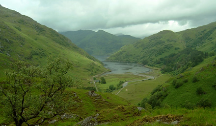
| Scotland is a part of the United Kingdom (UK) and occupies the northern third of Great Britain. Scotland’s mainland shares a border with England to the south. It is home to almost 800 small islands, including the northern isles of Shetland and Orkney, the Hebrides, Arran and Skye. Scotland is 274 miles (441 kilometers) long. The coastline is so jagged that it adds up to 2000 miles (3218 kilometers). At its widest point it is 154 miles (248 kilometers).
| | ||
| At its narrowest it is only 25 miles (40 kilometers). Because of Scotlands narrowness and its deep inlets, it is never possible to get far away from the sea.Scotland occupies the northern third of the islands of Great Britain. The river Tweed and the Cheviot Hills form Scotland’s southern border with England. The Northwest Channel separates southwestern Scotland from Northern Ireland. The northwest coast faces the Atlantic Ocean. East faces the North Sea. The east coast faces the North Sea, which separates Scotland from the mainland of Europe. | |||
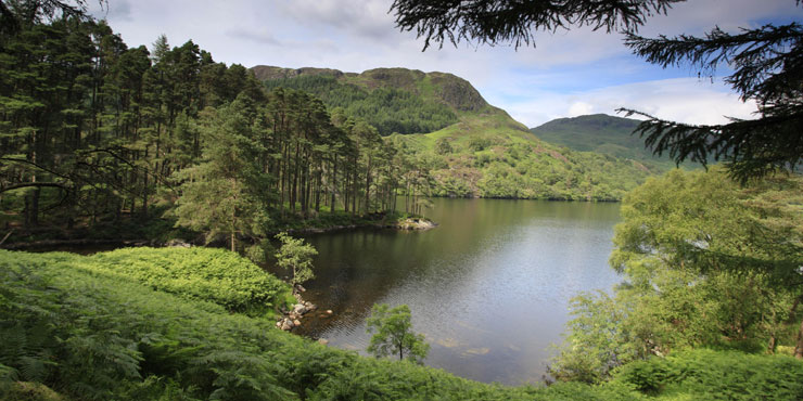 | |||
| Land Regions Scotland has three main land regions. They are, from north to south, the Highlands, the Central Lowlands, and the Southern Uplands. The Highlands Is a rugged, barren region that covers the northern two thirds of Scotland. There are two major mountain ranges, the Northwest Highlands and the Grampian Mountains rise in this region. The ranges have parallel ridges that run through the Highlands from northeast to southwest. A deep valley called Glen Mor or the Great Glen separates the two mountain ranges. The highest peak in the British Isle is 4406 feet (1343 meters). Ben Nevis, rises south of Glen Mor. The Highlands have two kinds of valleys. Steep, narrow glensand broad, rolling straths. Much of the land in the Highlands is a treeless area called a moor or a heath. The most rugged land lies along the west coast. Most Highlanders live on the narrow coastal plains. The Central Lowlands The valleys of the Rivers Clyde, Fourth, and Tay cross the Central Lowlands. This region has Scotland’s best farmland. Wide, fertile fields and low hills with patches of trees cover the entire region. About three-fourths of Scottish people live in the lowlands. The Southern Uplands They consist of rolling moors broken in places by rocky cliffs. The top of the hills are largely barren, but rich pasture land covers most of the lower slopes. Many sheep and cattle are raised in the southern uplands. In the south, the uplands rise to the Cheviot Hills. Islands Scotland has hundreds of islands. A large group of islands called the Hebrides lie off the west coast of Scotland’s mainland. The Orkney and Shetland groups lie north of the mainland and form the boundary between Scotland Climate Scotland does not experience any extreme climate and neither has it experienced Tornado, droughts or floods. But the day to day weather changes every day and generally the climate of Scotland is very unpredictable.The climate of the eastern coast of Scotland experiences a continental climate. The summers are very hot and winters are very cold. The islands and the highlands of Scotland experience west and southwest winds. Temperature January and February are generally the coldest months in Scotland, with the daytime maximum temperatures that ranges of an average of around 5° to 7 °C. July and August are normally the warmest months in Scotland, with temperatures of an average 19 °C.
| |||
For more information, please contact one of our offices
Study in Australia | Study in the UK | Study in Malaysia | Study in Canada | Study in the USA | Study in New Zealand


